

Further to reports in last week’s Rye News, another marine conservation zone (MCZ) has been officially designated that could affect the livelihood of Rye Bay fishermen. The site named as the Inner Bank, but probably better known to local fishermen as the Shelley Bank, covers an area of approximately 199 km square with its northern corner approximately 10 km south of Dungeness, extending south west across the 12 nautical mile territorial seas limit to waters south of Hastings in the English Channel.
The news came as a surprise to local fishermen, who claimed not to have been consulted. This was countered by Sean Ashworth spokesman for the Sussex Inshore Fishing Conservation Authority, who was positive that full consultation had been held. This in turn was confirmed by DEFRA, the Department for the Environment and Rural Affairs, but another official body, the Marine Management Organisation (based in Newcastle), is also involved in the process.
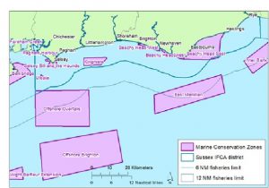
The designation may not directly affect local fishermen since the MCZ is too far out for Rye’s smaller fishing vessels to frequent, but there will be knock-on consequences, says John Botterell, as larger trawlers over 12 metres in length will be displaced and may move into Rye Bay to compete for their catch. Ronnie Simmonds, spokesman for the local industry, also considered that the designation was not in the interests of local fishermen.
The designation (by Order 2019/21 dated May 31 2019) describes the area as relatively rare for the south east region as it features “significant areas of exposed rocky reef. The rocky habitat is able to support a rich diversity of animal life, for example blue lobsters. Elsewhere in the area the movement of the thin veneer sediment which covers the rock can be colonised by a variety of species. The Inner Bank MCZ contains a variety of subtidal sediments ranging from fine sands to coarser sediments. The varied nature of the seabed means it supports a wide range of species, including several different types of polychaete worms, bivalve molluscs (such as native oysters), anemones, sea cucumbers, starfish, urchins, sea firs and sea mats.”
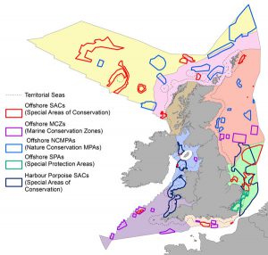
The MCZ designation is however seen as a victory for environmental campaigners like the Wildlife Trusts which claims that “over 22,000 people supported our campaign, calling for . . . better protection of our seas; , all 41 proposed Marine Conservation Zones were designated by the UK Government in 2019. This network of MCZs in UK waters will go a long way in helping to protect and conserve our wonderful marine environment and the diverse array of plants and animals which live there.”
Image Credits: Kenneth Bird , IFCA , DEFRA .
Interesting that Defra have used 10 kilometres as distance South from Dungeness then referred to the 12 nautical miles limit, says it all for me. Incapable of converting kilometres to nautical miles or just cannot be bothered.
For the dummies at Defra, MMO and IFCA 10 kilometres is around 5.4 Nautical Miles.
CA
PS: I know what the excuse will be—–our surveys are carried out using kilometres—–yawn.