
Rye had lots of serious ponding in January – when rainwater doesn’t drain away and collects in “ponds”, blocking roads and affecting traffic – and we in the Rye Emergency Action Community Team (React) have been working with professional partners to seek solutions. This work recently led us to investigate talk of a “reservoir in the Military Road”. Knowing that there are numerous springs in the location we set about finding the facts.
The geology to the north of the town is interesting. The so-called Hastings Beds have ancient Ashdown sandstone jutting from them. This type of geology provides an aquifer – a permeable layer – that retains rainwater like a sponge. The sandstone acts as a filter for rainwater and where the beds are exposed, such as at the base of Point Hill, the water escapes as springs. In the Military Road there is a clue to this long-term water activity: Spring Crescent is the name of the terrace of houses built for the military, who garrisoned the Royal Military Canal in the early 1800s.
While being careful to keep an eye on the traffic, anyone peering into the many road drains on the north side of the Military Road will see spring water flowing below. In some places it washes freely overground from north of the road into the drains on the south side, before reaching the outfalls to the River Rother or finding its way into the main sewerage system. There is so much water on the move that it gets everywhere, including into the gas main. In North Salts, spring water aggravates the road ponding after heavy rainfall and when the outflow to the river is closed off by high tide.
There was a time when the spring water was handled with more reverence and was collected for Rye. George Coleman, founding member of the Brede Steam Engine Society, writes that when Rye was an island connected by a narrow strait from Rye Hill to the Landgate, water from the Military Road springs was transported across to the town by boats in barrels known as “budges”. The main spring-fed well to the east of the Globe Inn in the Military Road became known as Budge Well or Budgwell.
In 1597, we know that Thomas Lashinden was granted the right to “lay a quill” [small water pipe] of lead or other material to link the Budge Well with the Postern Gate in Rye. At that time, Budge Well had a cistern built to collect and hold spring water.
In the 18th century, pipes were laid to extend the supply from the Postern gate to St Mary’s churchyard via Conduit Hill. In 1826, a pump was added to the system to lift the water. The pump house on the corner of Tower Street and Rope Walk can be seen today. Excess water in the churchyard cistern was diverted back down into another cistern seen in Wish Ward, opposite Rye Pottery.
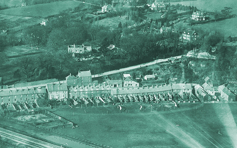
In 1892-4, the Budge Well cistern in Military Road was replaced with a huge underground storage tank or reservoir. A steam-powered pump station was installed, initially called Willow Tree Waterworks and later the Military Road pumping station (see main photo).
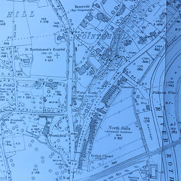
From the Budge Well storage tank of 53,000 gallons, the pump lifted spring water at a rate of over 8,000 gallons per hour up to another tank of 160,000 gallons at Point Hill. The installation at Point Hill was called the Playden Waterworks and is shown clearly as a circular construction on the 1927 Rye map (see above).
From Point Hill, water flowed by gravity back into Rye. Once these new waterworks were operational, the Tower Street waterworks were rendered obsolete.
By 1898, increasing demand for water led to a bore-hole and pumping station at the base of Cadborough Cliff, west of Rye. In 1935 the concrete tower cistern was built on Rye Hill to improve the gravity feed.
Budge Well provided source water until its closure in 1969. The reservoir at the Playden Waterworks in Point Hill was taken out of service in the 1970s, when a new reservoir in the west of Rye was constructed. It is thought that the Point Hill reservoir still existed until the 1990s, when Coleman suggests it was demolished.
What is left today is the redundant Budge Well underground reservoir in the Military Road. It lies beneath the western end of the white building of flats called Cliff Court. Stilts raise the western part of the building above the tank. Ownership of this site has passed from the early private companies to Rye Corporation, then to the Water Board and on to the privatised Southern Water, which still owns it. The Company reports that although redundant, the tank is periodically pumped out, the last time in 2014.
This research has located one reservoir in the Military Road, but is there another farther to the east? There are indications that there is.
As for Budge Well, some might find it disturbing to consider that in 2015, spring water that was once a valuable resource for Rye is now allowed to run into the drains, increasing localised flood risk, before it eventually enters the sewerage system or the river.
With our water under French ownership, will we ever hear in Rye restaurants: “carafe d’eau? Source de la route militaire?”