

In November 2019, Rother District Council announced that it had received a grant of £163,272.60 from the Rural Payments Agency under the European Agricultural Funding For Rural Development Tourism Infrastructure grant programme, for the 1066 Walk Pathways (WPP) Project.
In the report to Cabinet, the objectives of the 1066 Pathway Project were set out as follows: “The 1066 WPP aims to significantly improve and enhance the signage infrastructure and promotion along the 31-mile Pevensey to Rye 1066 Country Walk route. The pathway route exists and benefits from enhanced maintenance by East Sussex County Council (ESCC); however improved signage and promotion is needed in order to raise awareness and increase usage of the route.
“The Project’s overarching aim is to support rural businesses by enhancing the 1066 Country Walk as a quality visitor attraction, encouraging longer visitor stay and spend, attracting a broader range of visitors and encouraging year-round use.
“The Project will create and install bespoke visitor interpretation panels along the route reflecting local history, visitor attractions, eateries, accommodation etc along with two bespoke sculpture pieces, bespoke seating and sculpture trails, and enhanced promotion of the route.”
Town Council was not asked
It would appear, however, that at no time was Rye Town Council asked if it wished to be involved and Rye Conservation Society (RCS) only became involved when one of its Executive Committee members heard about it late this summer through a local rail user group. The RCS fielded two members to assist in providing background information for the bespoke visitor interpretation panel, but was astounded to learn during this process where the panel for Rye was to be located.
A search of the internet gives varying locations for the start of the 1066 Walk in Rye. The High Weald AONB website gives Strand Quay as the start whilst the Long Distance Walkers Association indicated Gibbet Marsh car park as the starting point. More bizarrely the 1066 Country online map shows the walk starting where the Strand Quay to Gibbet Marsh footpath crosses the railway line!
So where has Rother decided to signify the start of the new improved and enhanced route? Not at Rye railway station, the most logical location, or outside the Heritage Centre on Strand Quay, where it would intersect with a number of other local walks including the Saxon Way and the Military Canal walks. The location for the new information board and possible sculpture is to be at the old pumping station on West Undercliff, not in the centre of Rye and where any signage is likely to suffer from vandalism.
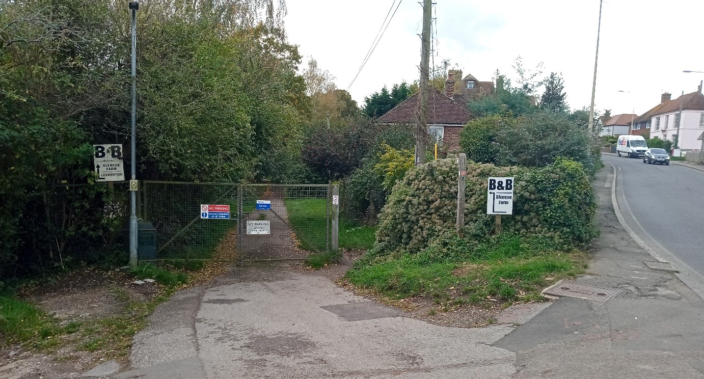
Any visitor arriving the station, where the only information provided is to be a leaflet, will probably walk to the start via Ferry Road and Udimore Road and will be faced with the unremarkable sight of an access gate and various signs, hardly the most inspiring start to this prestigious tourist route.
If they start from the soon-to-be-re-opened (Covid-19 permitting), Heritage Centre on Strand Quay, there are no signs giving the route from there to the pumping station and its information board.
Rye Conservation Society has been told by Councillor Timpe, Rother’s lead councillor for tourism, that “we do value the input of local organisations and residents. This lengthy project has now moved beyond the planning stage and we are into delivery. The EU funding comes with both strict delivery and claim criteria and therefore we are not in a position to alter the design to any significant level”.
A lack of consultation
Had Rother consulted on this project at an early stage with those areas through which the 1066 Walk passes and asked the right questions of the right people at the start we would not be in this position. They did not consult Rye or seemingly any other of the villages along the route.
One might think that those running the project were more concerned with the provision of the artworks than with delivering a user-friendly route from Rye station to Pevensey station and all the other stops along the way. In the age of the internet and mobile phones, why has the opportunity apparently not been taken to deliver information in a digital format and coordinate a common start or finish point across all online sources?
In the case of Rye, what the society would like to see is the information board with a suitable QR code relocated either to outside the station in the John Ryan Garden or by the Heritage Centre on Strand Quay with the QR code displayed at the station. Same board but just in a different place. This needs then to be combined with suitable signage from whichever point to the 1066 walk at the West Undercliff pumping station.
Even at this stage, such changes should be possible without major financial cost and would be to the benefit of all future walkers and visitors and will help to achieve the aims of the project which in our view it currently fails to do in Rye.
Image Credits: Julian Luckett .
It does seem a monumental error for Rother DC to fail to discuss this project with an appropriate group in Rye such as Rye Town Council. The grant received of £163,000 is a significant amount of funding for revitalising the 1066 Walk, effectively to promote tourism, a vital activity for all towns and villages along the Walk’s route. With Rother DC’s tourism brief being responsible for the project (or, at least, being deeply involved in the project), you would have thought it would have occurred to them that local tourism interests at each stop along the route might want to contribute their own thoughts about the content and location of the information panel and on the wooden sculptures being commissioned.
I agree with Julian that the current end-point of the Walk in Rye is badly located, particularly for train users. Amongst its range of objectives, MarshLink Action Group (“MLAG”) aims to promote local tourism by the use of the MarshLink rail services and one can imagine that, with a 31 mile walk coinciding with several stations along its route, many walkers might like to avoid the inconvenience of a car and travel the route in sections between train stations. So, to locate the information panel at the station or, indeed, the Heritage Centre in Rye would seem appropriate and apparently not inconsistent with the original route of the Walk.
Having failed to consult Rye about the project at an earlier stage, it seems reasonable to invite Rother DC to belatedly take note of our thoughts and make appropriate adjustments.
Stuart Harland
Chairman, MLAG