

As part of Network Rail’s ongoing rationalisation of footpaths across railway tracks, it proposes to close both pedestrian crossings at Mill Bridge by Rye windmill.
Network Rail’s recently submitted planning application to Rother District Council (RDC) includes a pedestrian bridge over the River Tillingham as well as a footpath under the railway track (see diagram below).
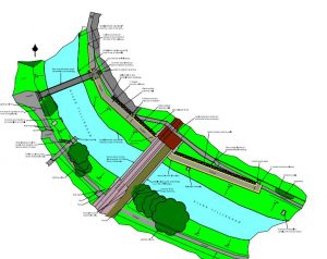
The proposed changes will create a pedestrian link between the Gibbets Marsh car park and The Strand with pedestrians no longer having to walk across the railway tracks.
The scheme was first proposed to the Environment Agency (EA) back in 2015 as part of National Rail’s “National Level Crossing Risk Reduction Programme”. EA’s initial response was that it had no objection to the proposed underpass on the left (east) bank of the Tillingham though had asked for further detailed drawings to demonstrate that the proposed works will not reduce the capacity of the river.
While the new river crossing and path should provide a better link for pedestrians, the reasoning behind the scheme is to reduce the number and type of level crossings across the country. The Mill Bridge crossings have been identified because of concerns expressed by Network Rail. In the planning application it explained that they have “experienced a significant number of incidents of abuse with 14 incidents recorded since 1999, there were three reported incidents in 2017. It is important to acknowledge that these are only reported incidents and there may be other incidents that have gone unreported. There have been a number of incidents of near misses and crossing misuse dating back to 1999”.
The proposals also include a new ramped walkway to re-route the existing north-east footpath. The footpath will include 1m-high river walls running parallel with the River Tillingham to prevent flooding. This work will mean the removal of two mature sycamore trees, two elder trees and a small ivy shrub from the northern bank of the river to allow the re-alignment of the footpath with the river wall.
The proposed closure of Mill Bridge level crossings and construction of a new footbridge over the river should provide a safer and more pleasant route for pedestrians using Gibbets Marsh who want to access the town centre. This would also be a useful enabler for the eventual speeding up of train services, should high-speed train services be extended to Rye and the Marshlink.
The application is currently out for consultation and you can have your say here. A decision is expected on September 18, 2018.
Photo: Kevin McCarthy
There used to be a foot bridge over the Ferry road crossing for use when the gates were closed.
It would be useful to get Network Rails costings for the work, especially in relation to the bridge element to compare with ESCC’s costings for the proposed cycle bridge the other side of Ferry Road.
If the footpath goes under the rail bridge,it will be impassable at times,in the event of heavy rainfall,the river gets very high
With faster and quieter trains, personal safety for pedestrians crossing the railway tracks is of prime importance. Unfortunately these particular crossings do not have any warning system in place to indicate an approaching train. Therefore anything that makes these crossings safer must be beneficial to all.
On the face of it this proposal is a good idea, as it will improve the safety of pedestrians. I do have two main concerns, the first relating to the application itself, the second relating to the decision-making process for using public funding.
My first point. The documents submitted with the application are wholly inadequate. If I as an architect struggle to understand them, what hope for laypeople? There is no general arrangement plan, which would provide information on levels and gradients, nor is there a longitudinal section, so we cannot tell what the gradient of the path is and what implication that would have for less mobile people. The closed level crossing to the South-East side of the river is not included in the application site – why not? There is no explanation as to how the height of the wall protecting the path underneath the bridge has been worked out, so there is a legitimate fear that the path is vulnerable to regular flooding. There is no information on whether the path or bridge are suitable for cycles, or a wider transport study to better understand the peak capacity requirement. Rother DC should not be validating applications that are this poor.
My second point. There is within the Neighbourhood Plan a proposal for a new bridge and path to connect the schools and sports centre to Tilling Green, better known as the Rye Greenway and regularly discussed at town meetings. This has been costed at about £900,000 by East Sussex County Council. Even though ESCC currently holds £230,000 and Rother DC £45,000 towards the project, there is no realistic prospect of this project ever proceeding. As some of you may be aware from recent national news coverage (and I’m slightly surprised this issue has not been covered in the local news!), ESCC is facing bankruptcy within three years unless services are cut to the bone. Network Rail are publicly owned and funded, so who has made the decision that the bridge they are currently proposing at Mill Bridge, to achieve a marginal safety gain, is of a higher priority than the Rye Greenway bridge across the Tillingham River, at what one can assume is of a similar cost? Just as with our schools, there is a democratic deficit in the decision-making process, with our district councillors, county councillor and MP (all Conservatives, as is the Government) being utterly impotent or disinterested in how public money, precious as it is, is used locally.