

With only weeks to go before Rye elects a new Town Council on May 2, and possibly votes on its Neighbourhood Plan, the current councillors may have one last major planning issue to consider.
Developers Martello have already consulted the public on their plans for a new arts centre and some housing (see model above) which were welcomed by many.
But councillors will have learnt from the long process of developing Rye’s Neighbourhood Plan that the devil can be in the detail.
The stretch of Rock Channel on which Martello plan their houses can be accessed only from a dangerous junction with the busy South Undercliff A-road at Strand Quay.
And for major events at the new centre the developers expect the audience to park elsewhere, most probably in the Gibbet Marsh car park.
But plans to improve the pedestrian route from Gibbet Marsh to Rock Chanel were withdrawn – though Network Rail deso want to remove the need for pedestrians to cross the railway line.
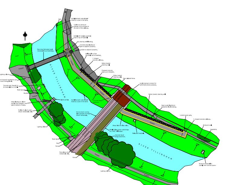
Currently, at night, this route is a poorly lit , sometimes overgrown path, marked by large puddles in heavy rain, from Gibbet Marsh to the Winchelsea Road – and the railway’s plan (once revised) would be very welcome.
And it has been suggested that the developers might organise some sort of “park and ride” when there are big events at the new centre.
Also, because of the flood risks, most of the new housing will have ground floor parking – as does the initial, just completed, Bridge Point housing , on the market with a million-pound-plus price tag. So on-site parking may not be an issue.
However Rock Chanel is a cul de sac with more than 20 homes and a few businesses (now including an auction house) beyond the proposed development so it cannot be traffic free – even if one ignores Jempsons juggernauts turning into and out of their adjacent land.
So, even if the architects’ model (above) looks okay – particularly from the lofty heights of the citadel and St Mary’s at the top of the town – the councillors will need to look at wider planning issues, and the possible knock-on effects of this development.
The proposal, however, does deserve a cautious welcome, though it seems unlikely to deliver much in the way of affordable housing, and it may add to Rye’s existing traffic problems.
On the other hand it may help lift the negative hand of the Environment Agency on development in this area around Strand Quay and Rock Channel.
Image Credits: Martello Developments , Network Rail .
“Currently, at night, this route is a poorly lit , sometimes overgrown path, marked by large puddles in heavy rain, from Gibbet Marsh to the Winchelsea Road” That is totally incorrect, I have never seen it overgrown or seen large puddles and the lighting is perfectly sufficient at night.
I used to walk this route twice a day for 3 years & yes when there was heavy rainfall a huge puddle covered the end of the path as you get to the back of houses on Winchelsea Road. Luckily I could just about stretch to get over it, but some people would not and it was very deep!! Also the path at times was very overgrown.
Rye has never had such a good opportunity to develop a large central location before. A new vibrant arts centre, outdoor free to use public space and removal of unattractive warehouses plus new access to the river. There hasn’t exactly been a line of people with alternative plans nor the funds to do it. As to it being a “dangerous intersection” one could name a half dozen more dangerous. Zebra crossings and signage could reduce “dangerous”, which are missing in other locations in town (e.g. intersection of Military Rd and Rye Rd, in front of Cinque Ports pub, Landgate at Cinque Ports St).