
East Sussex County Council (ESCC) are currently consulting on their Local Cycling & Walking Infrastructure Plan which includes an appendix with detailed proposals that set out the potential next steps to help make Rye more walking and cycling friendly.
Produced for ESCC by Sustrans, the walking and cycling charity, the document outlines some infrastructure improvements and traffic calming proposals to create an environment that encourages more people to walk and cycle the short distances to work, school and to the shops.
Sustrans themselves admit the plans could be controversial. This article aims to summarise their proposals but if you want to read the full report, at 58 detailed pages plus maps, click here.
Sustrans was originally commissioned by ESCC in March 2017 to support the development of their countywide Cycling and Walking Strategy. Their role was to “identify new and improved walking and cycling routes and infrastructure that align with key council policies and programmes that support local economic growth, improvements to health and well-being and the environment, together with the engagement of key local stakeholders.”
Town is often gridlocked
Sustrans recognise that “the town suffers from congestion due to a high volume of vehicular traffic and HGVs on the narrow and limited range of roads that pass in and through the area. The centre of Rye has a one way system to help manage this, but in the summer months and other busy times congestion is exacerbated and the town is often gridlocked.”
They go on to say that Rye “is ideally suited to having a high number of active travel users, but the road network and the need to further improve the provision of dedicated walking and cycling facilities makes this an undesirable option for many people due to perceived safety concerns.”
They expand this to say, “the quantity of heavy traffic within the town and main roads makes it uncomfortable for cyclists to use the existing road network and limited off carriageway provision reduces the number of people using active travel means.”
“To allow safe and enjoyable walking and cycling access to the historic centre of Rye it will involve significant changes to the vehicular access to the narrow medieval streets” Sustrans adds.
On the barriers to walking and cycling, Sustrans say, “The existing one way system enables vehicular access to the High Street, East Cliff, The Mint, Cinque Ports Street and Tower Street and limits the accessible routes into the town for cyclists to Ferry Road, or Wish Street, or forcing them to negotiate significant gradients, steps or dismount and walk up a one way street on the pavement.
“The roads are congested with HGVs, vans and coaches while being narrow, or dual lane one way, exacerbated by a significant quantity of parked cars. Narrow footways with limited dropped kerbs and safe crossings provide an uninviting environment for cyclists and walkers alike.”
Recommendations making it safer to walk/cycle
As a solution, Sustrans make several recommendations:
- Improve pedestrian facilities as a priority over maintaining speed and quantity of vehicular movements or parking on narrow roads;
- Improve legibility and wayfinding for safe designated pedestrian and cycling routes;
- Provide alternatives to cycling on carriageway for the busiest routes, this can be on-road, or off carriageway as a shared or segregated path, as feasible in each situation;
- Increased number of safe crossing points throughout the area, especially in areas of higher pedestrian density, such as Rye town centre;
- Provide safe accessible links to the national cycle network to allow easier access for more people.
In addition, Sustrans recommends a series of more detailed measures to “improve the environment for walking and cycling. These will be controversial and require a more detailed analysis, as well as public consultation. They will improve the environment and protect the historic character which makes Rye so special.”
Reversing the one way system
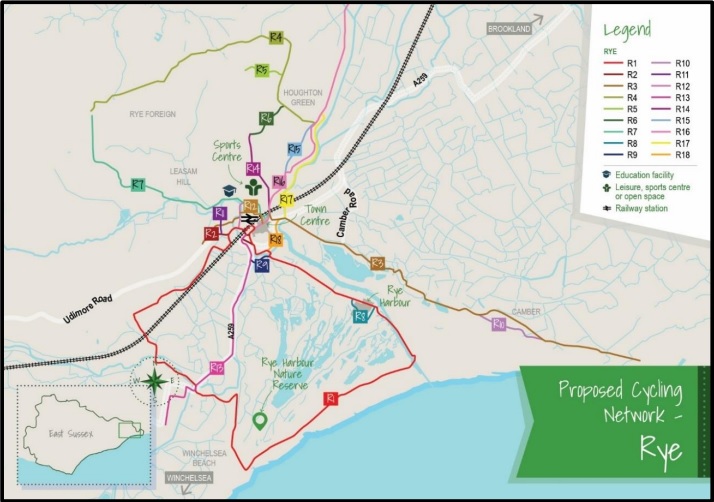
The map in the main picture above shows their recommended changes to the town centre. In summary they are:
- Reverse the town centre one-way system, so cars enter at The Deals [at The Strand], and exit at the Landgate;
- Limit vehicular access into Rye town centre to all except essential deliveries and residential access;
- Reduce the quantity of on-street parking in the historic town centre and provide additional parking outside this area for those needing to access the town centre;
- Several junction closures are proposed that will enable access but restrict through traffic. This includes each end of Cinque Ports Street, Strand/South Undercliff, Wish Ward/Ferry Road and along Cyprus Place;
- Enter and exit Station Approach from Ferry Road, with no through access to Cinque Ports Street;
- Redirect access to station parking so cars enter at Station Approach and exit on Rope Walk;
- Create an “access only” one-way system to Deadmans Lane, The Grove, Rope Walk, Tower Street and Landgate to allow access to the school site and homes along those roads;
- Improve shared facilities on existing bridges and provide an additional shared use bridge linking the Rye Harbour Road and Rock Channel.
The proposals also include a new bridge and path over the river Tillingham, from Tilling Green to the school site, and better pedestrian access via the railway tracks to Gibbet Marsh car park.
In all, it is an ambitious plan for Rye and it remains to be seen how well each element of the plan is received and taken forward.
Image Credits: Sustrans , ESCC .
Some excellent suggestions here, but I see no recommendations for Military Road. A proper pedestrian crossing, one with an on-demand traffic signal, just north of the railway bridge, would greatly improve safety and might also slow down the drivers who think that 60 mph is an acceptable speed up the London Road.
My elderly mum lived in Military Road and I was constantly worried that she would be knocked over negotiating the busy road north of the bridge. I wrote to ESCC with my concerns and they replied there was no need for a crossing as there was no evidence of a safety problem, nobody had been killed or injured.
I would like to thank the developers of this detailed and thoughtful plan. It’s impressive in my opinion, and makes the residents of Rye front and centre as we are the ones who use the town on a daily basis all year round. It will make it more pedestrian friendly and welcome visiting cyclists and hikers.
Imagine a High Street with cafés spilling onto the road with only deliveries to deal with? Instead of crowed pavements, one will be able to easily stroll in the street. I think it will positively change the ambiance of the town and help to decrease the impact of the automobile.
A few observations. The buses don’t seem to have an easy way to access leaving the town from the current bus depot near the station. It also looks like the Cattle Market car park might be more difficult to access? The latter could easily be corrected with a new access from the train station lot (albeit losing 2-3 train station spaces). Although hugely controversial and expensive, to help increase parking options, an attractive double decker parking garage could be constructed at the cattle market location (with planted side gardens and the first floor half way dig underground to minimise height). I have seen these in France and Spain and they work surprisingly well.
Reading these ambitious plans for Rye, haven’t we over the years seen similar before, we lost the chance for a bypass over 30 years ago thanks too the Nimbys, and Rye has suffered from congestion ever since, and the only way forward is get the bypass back on track, with adequate park and ride for all visitors to the town, that is the only forward to ease the congestion and mayhem that we see daily in this town.
I don’t think it was Nimbys who opposed the bypass, it was the whole town as I the campaign was called ‘ Around not Through’ The proposal was to cut the town in half and the town suggested other routes which were a real bypass but not accepted.
I’m glad the plan includes ‘Improve legibility and wayfinding for safe designated pedestrian and cycling routes’. Will that mean improvements to the cycle route between Rye and Winchelsea, the overgrown quagmire from Gibbet Marsh to Dumbwomans Lane? Before we start thinking big perhaps ESCC could carry out some maintenance to the existing paths?
Really good to see such a forward-looking plan and it would be encouraging to see it taken to the next, more detailed stage.