

The Rye Neighbourhood Plan is a “living document”, which requires periodic review to ensure that its policies are being regularly considered by Rye Town Council.
Of three recent pieces of work for the Rye Planning and Townscape Committee – affordable housing, the strategic gap with Rye Harbour, and land instability – the last has just been seen as particularly relevant by Council as there is a certain amount of vegetation removal in parts of Rye that has exposed the underlying soil and rock.
Rye stands at the point where the (mostly) sandstone high land of the Weald reaches the coast and the part of the town, known to many as the Citadel, sits on rock which has resisted coastal erosion – and it is a separated part of the high ground to the north and west of Rye that is the eastern part of the High Weald. This is made up of faulted strata of sedimentary rock known as the “Hastings Beds“, the underlying structure of which is porous, relatively soft rock susceptible to water permeability and erosion – and the many springs which egress from the base of the high ground to the north of Rye result from rainwater filtered through the porous “beds” and flowing to lower points.
Landfalls and slips do happen
After extreme rainfall events – and these are becoming more frequent – or after frost and ice has acted on crevices, occasionally there are landfalls and slips at weak points on all of Rye’s south facing rock edges.
Historically, there have been large falls at places such as the western edge of Ockman Lane off East Street in the Citadel and at Point Hill, off Rye Hill, where large quantities of rock have been displaced in the past.
More recently, small falls have been seen from the Cadborough Cliff face in 2019; from above Military Road (behind the Globe and Cliff Court) in 2014, and in places below the west end of Watchbell Street and Church Square below the Gun Garden.
Ground works increase risk
Ground development work and the over zealous removal of vegetation risks an adverse impact on the relatively soft rock and its top soil covering – and the final result can be a higher risk of land slip. Experts in this field recommend that as much vegetation as possible should be retained to stabilise the top soil, and that storm water runoff should be carefully directed away to prevent the liquefying of top soil and the weakening of the rock under layers.
Remedial work has to be carried out by experts who do not aggravate the problem as those adding concrete might create points of new weakness into which water and ice can act.
This is a planning matter
To prevent land owners increasing the risk of instability is a planning matter and national policies and local ones in the Rother Core Strategy, the Rother Development and Site Allocation document and in the Rye Neighbourhood Plan all recognise this risk, identify high risk area locations – parts of Rye are included – and set policy to monitor and mitigate.
Planners should recognise any site specific risk and ensure that their decisions do not aggravate the situation. Where land owners take unilateral action, perhaps prior to development proposals, as seen in places now such as the Undercliff, beneath Rye Hill particularly on the north side of Military Road, and land under New England Lane (also above Military Road), their actions should be subject to enforcement action to ensure appropriate mitigation.
Rye is certainly built on rock, but it is relatively soft and permeable rock, and needs to be treated with great respect. As our forebears have seen, careless works can cause damage which could result in those on high ground ending up at sea level.
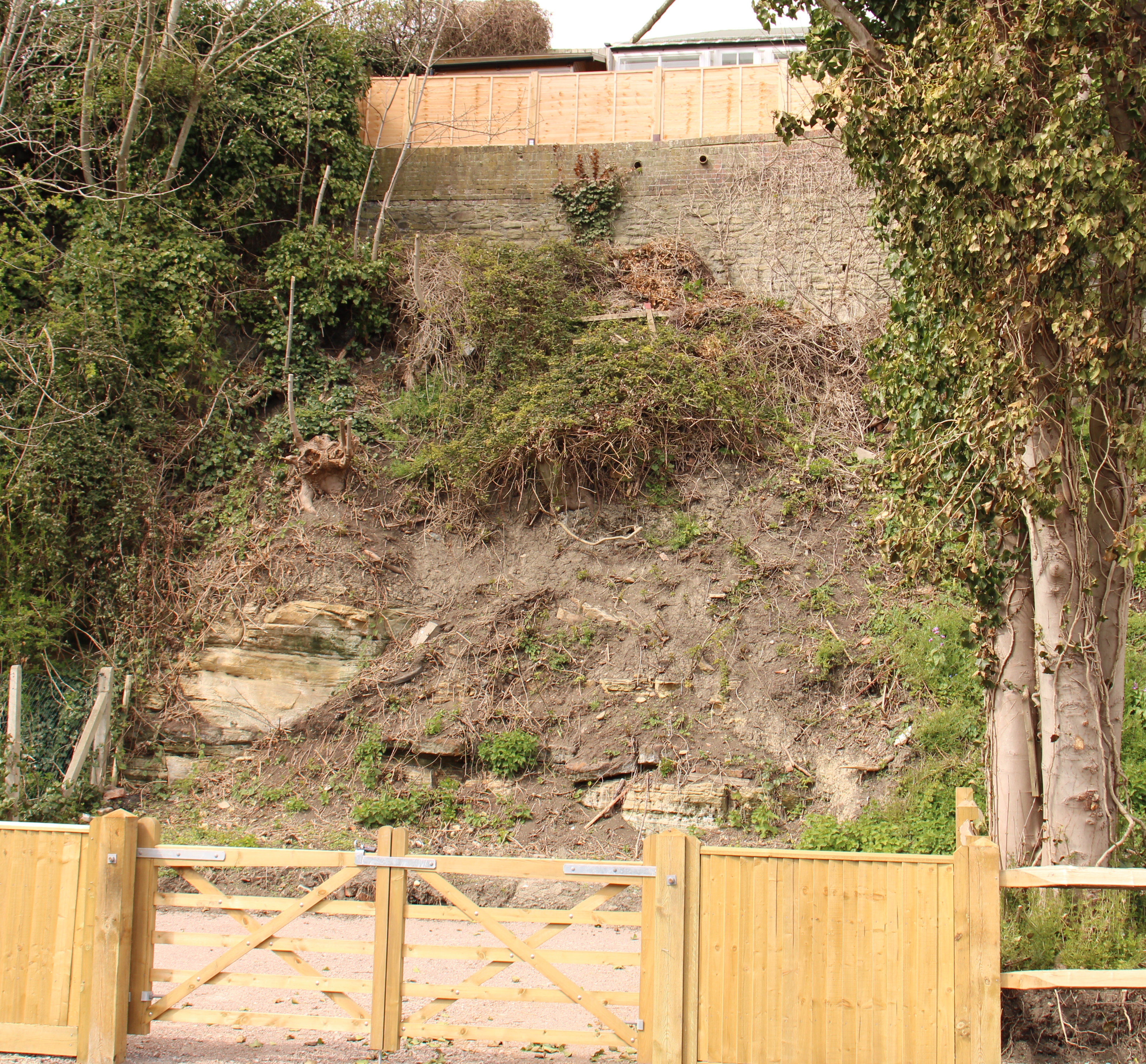
Image Credits: Anthony Kimber .
Roughly a quarter of Rye’s area was lost between 1370 & 1375 when a huge area of land between the site of (now) Knoops Chocolate Shop and Ockman’s Lane crumbled away.
(This is why the road through the landgate suddenly veers right after Knoops – originally it carried straight on into what is now thin air and joined up with the sheer drop at the end of Ockman’s Lane!)
The monastery in Conduit Hill was originally sited at the end of Ockman’s Lane and had to relocate to its current location in 1380, after the original buildings vanished over the crumbling cliff.
Although the sea no longer laps at the base of our cliffs, the rock of Rye is still unstable; Colonel Kimber is absolutely correct about the need to retain the stabilising vegetation!
Thank you for this very timely article. Owners of Tideview on New England Lane, Playden have proposed a large extension, swimming pool and studio on land immediately above the cliff on Military Road. Homes below the cliff in question are in Rye. There has been intense opposition to the plan but it has yet to be decided by Rother Planning Department. The architect, based in the Creative Centre here in Rye, appears dismissive of these concerns (one can read his response on the Rother planning Portal). More alarming, no geologist was consulted. They also have overly trimmed trees and removed some, in order to have a better view, as one of the owners of Tideview told me, but did not respond to my concerns about erosion and land instability. A better view for one property but it places many properties in a potentially dangerous situation in the years to come. Strict enforcement of building and vegetation removal is essential and must begin at the local council level (Rye and Playden in this case) and supported by Rother.
I should say for the public record that I have spoken with the owner of land illustrated in this article and am aware of planned stabilising measures.
The article might make unwelcome reading for some but, as others have commented both here and in recent letters to me, given the nature of the local geology, the risk of landslip and rockfall is very real and can have serious impacts. For that reason, planners should be alert to any proposals that increase the risks.
If insurance companies get wind of possible problems in parts of Rye, land instability, subsidence and so on, then it may become increasingly difficult to get cover at economic cost, or perhaps not be able to get cover at all. Be warned, and bear in mind that there is a duty to disclose hazards of which insurers may not be aware.
Totally agree with Paul that strict enforcement of building and vegetation must be controlled at local level in these situations. It was nearly a year ago when we had the serious landslides in Military road and some home owners are still in rented accommodation having had to leave their homes.