
For four mornings and three nights Rye’s tide has been at its highest level for the whole of the year. And the photo (above) from the Ypres Tower shows the sheer volume of incoming water should the defences fail or be overwhelmed. However the problem can be much, much worse if the high tide combines with a “North Sea surge”.
At Thursday lunchtime, and the day before, the tide spilled over at the Strand, and began to edge upwards across the car park past the large concrete blocks. But, unlike the month before, there was no ponding in the Winchelsea Road just over the Tillingham Bridge from the town.
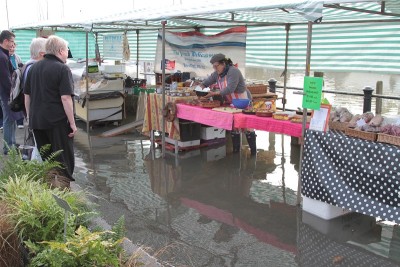
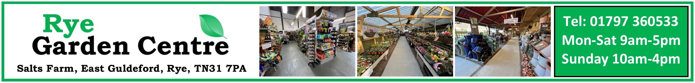
However the Farmers Market suffered on Wednesday as the water pushed customers back from the quayside stalls and those with fine eyesight may see how (in the top photo) water has spilled over the Rock Channel quayside and under parked cars, moving steadily towards the road.
Following this week’s experience it seems likely that the stalls for the Farmers Market may have to move up the slope a bit. A month ago the water was just lapping into the back of the stalls under the canvas. But this time the water forced customers back from the stalls, and one stall holder (lacking wellie boots) abandoned ship, after rescuing what boxes and crates he could.
Botterells with their sea harvest of fish, crab and other delicacies should have looked more at home, but the water was relentless in its advance – even after the High Tide time listed in local tide tables. The French Delicatessen stall on the other hand found imaginative ways to balance above the water while carving up cheeses, and Kristin Watt-Boner from Hawkhurst’s “Gorge on Gorgeous” seemed the most relaxed (but then she had arrived in boots). And the garden stall managed to stay well above water level.
But the picture in December 2013 was much worse. The flood gates had had to be closed, the car park had become a lake, and the water level was only inches below the top of the surrounding walls, and spilling over and pouring into the Strand area.
However metres had been added to the normal tide level by a “surge”, which had been forecast by the Meteorological Office, and REACT (the Rye Emergency Action Community Team) led by Colonel Anthony Kimber were on stand-by
Weather systems, usually low pressure and called cyclones, can drive increased tide levels down the North Sea, flooding neighbouring countries, and this effect is made worse when the North Sea water is driven into the shallow and narrow English Channel.
The cyclone in December 2013, called “Xaver” by some, caused water levels up to five metres (17 feet) above the predicted tide level. Ten such incidents causing widespread flooding were reported in the last century, and 15 “surges” were reported between 1883 and 1979. So far this century there have been four.
In 2013 in this country “Xaver” shut down railways and bridges, caused ferries and flights to be cancelled, thousands of homes lost power, 1,400 homes were flooded in England and Wales – and at Dover the tide was 4.72 metres above the expected datum level.
Down at Rye Harbour the water flooded the nature reserve and was inches below the top of the flood wall, which (worryingly) was many inches above the top of my caravan. Similarly at the Strand the water around the quayside within the flood walls was much higher than the surrounding streets and pathways. And the statistics suggest such a “surge” could happen every 4-6 years.
The Town Council recently proposed to add “assisting with flood responses” to the Town Steward’s job description which may include providing and placing sand bags for homes at immediate risk ; and putting up “flood” signs to warn drivers – particularly as there are frequent floods at some spots because of inadequate drainage.
Photos: Ray Prewer
Image Credits: Ray Prewer .