

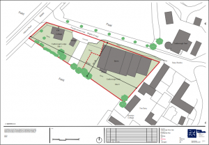
In surprise move, a planning application has been submitted to Rother District Council to demolish an agricultural barn and an adjacent cottage and replace them with five detached houses on the approach to Rye at the top of Udimore Road.
The surprise is that the developers submitted an application at all considering Rother’s planners visited the site for a pre-planning consultation in December 2018 and said they would not support such an application if it were to be submitted.
The developer’s main argument is that building the houses will help alleviate local housing need. The five houses will be quite large and comprise of three and four bedrooms.
The reasons for the initial refusal is that the proposals are outside Rye’s development boundary; too close to the High Weald Area of Outstanding Natural Beauty (AONB); and would obscure the listed Cadborough Oast house that sits at the top of Udimore Road.
The planners went on to say “A residential development of this whole site at the transition between Rye’s recognisable built up area and the open fields and AONB beyond be inharmonious and would result in unacceptable harm to the character and appearance of the area.”
Rye’s Conservation Society (RCS) and Rye Town Council were quick to outline their respective objections to the application that echoed that of Rother’s planning department. The RCS reiterated that the site lies outside the development boundary for Rye, which was recently agreed and set out in the Rye Neighbourhood Plan in 2019.
The RCS also pointed out some mistakes they believe were submitted in the plan, saying, ‘the assertion that the rear hedge of the site towards Udimore represents the historic boundary of Rye is fallacious” and went on to say, “Currently the edge of Rye coming from Udimore is defined by the housing and mature trees along Oast House Drive and the current site exhibits an open agricultural landscape which is the correct setting for the listed Cadborough Oast.”
Quoting the Rye Neighbourhood Plan, the RCS pointed out that the designation of a development boundary is, ‘to preserve Rye’s unique setting, particular control over development will be applied to conserve and enhance the open landscape on the edges of the Town’. In a short submission to Rother, Rye Town Council also raised similar objections.
In a further blow to the application the High Weald AONB Unit said it “objects to the proposed development on the grounds that it would be a very suburban form of development out of character with the farmstead and damaging to the setting of the AONB.”
Readers may recall that a proposal for a petrol station along this stretch of Udimore Road was turned down by the government’s planning inspectorate following an appeal by BP.
It remains to be seen what Rother’s final decision will be but you can read the full planning application here.
Image Credits: Rother District Council planning application .
Interesting to see developers trying to get permission on the old cadborough farm site, one wonders why the Rye boundary signs have crept a way from the top of udimore road over the past few years towards Udimore,and that is probably why the developers think it is in the Rye boundary, if it was for social housing for Ryers,i would be all for it, but not for expensive detached houses,for second home dwellers,as the town seems full of them.