

[Editor’s note: Town hall agendas, and Rye News, often focus on small examples (like a dangerous road, pictured above, or a single building site) of bigger problems – like affordable housing and overall transport issues – so it is good to be reminded of “the big picture” and long term strategies – which is what neighbourhood plans strive to address, and Rye has one – and the town council has been trying to think strategically in recent weeks despite the day to day Covid headlines – as Anthony Kimber reports below]
Seeing that the Battle neighbourhood plan is out for consultation this week, reminds me of the work that went into the Rye neighbourhood plan from 2013 to agreement last year, as neighbourhood plans remain relevant for communities as they are statutory documents and provide one of the only ways that local people can influence planning matters. And, even under the planning changes being proposed by the current government, neighbourhood plans remain supported.
And there was lots of wide ranging business at Rye’s Planning and Townscape committee meeting on Monday this week as the committee does not just scrutinise planning applications, but also considers strategic matters as they arise and business touched on to Rother traveller sites; Cyprus Place proposals; social housing and “connectivity” (in particular pedestrian and cycle paths across Rye).
First, social or affordable housing is a subject that has arisen throughout the work on the neighbourhood plan and Rye Town Council is looking to raise visibility of this again. Previous pieces in Rye News have described how developers are able to avoid the provision of “affordable homes” from their contributions because the rules allow them to demonstrate “low viability” of the scheme, or because they strike a deal with Rother District Council (the local planning authority) to channel funds elsewhere into infrastructure.
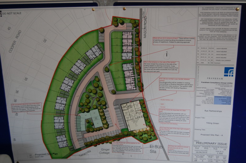
Looking at the major developments in the pipeline such as the Ferry Road (Lower School Site) or Rock Channel, little in the way of affordable homes is on offer. An alternative to developers’ provision is for Rother District Council (through its Alliance Homes initiative) or Rye Town Council to lead their own schemes.
Less than half affordable
The former is looking to do just that in Cyprus Place, on their own land (a former depot) but against opposition from many in Rye because of the loss of the services and employment at Rye Hire. The initiative has been short on local consultation, but we learn that, of the homes proposed there, less than 50% could be social or affordable, with the larger number being for open market.
The provision of homes to enable local families on low incomes to get on the property ladder is complex and involves a consideration of many factors including of course the impact of second homes and homes for holiday lets. One of the alternative ways to provide such dwellings involves Rye Town Council leading its own scheme, perhaps in partnership with a “not for profit” association or developer, or under the community land trust arrangements, or even to allow individuals to self or custom build to a set of design requirements.
The start point for all this is the need for land. There are possibilities in Rye – all identified in the neighbourhood plan – such as the Tilling Green former school or parts of Rock Channel or the former Freda Gardham school. Securing land would take negotiation with the owners but it ought to be possible, particularly where there are no firm proposals coming forward. This business should remain high on the agenda of Rye Town Council.
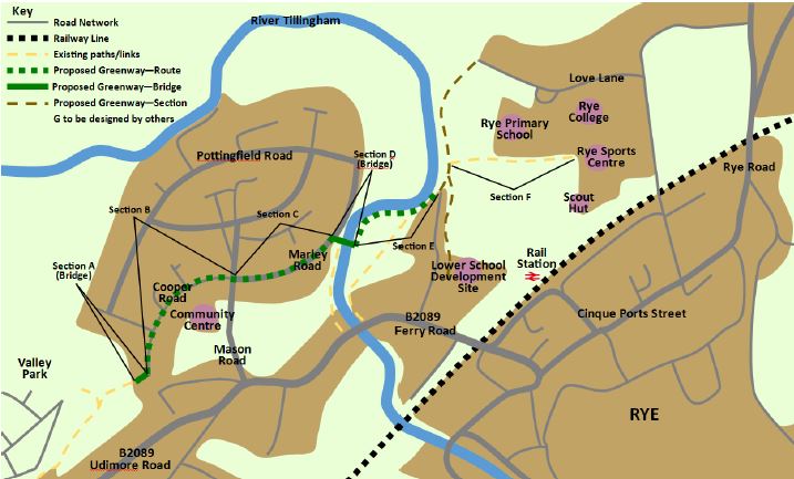
Secondly, initiatives have recently emerged which could improve connectivity across Rye for both pedestrians and cyclists. This is particularly relevant now, as the MP for Hastings and Rye has confirmed that new funds for “levelling up” could be available to East Sussex County Council for local projects such as improving routes for walking and cycling and other infrastructure including social housing.
Two recent proposals, one by the 1066 organisation to renew signs for its paths and another by East Sussex County Council to improve “access for growth” through better walking and cycling infrastructure have been considered by the town council and, rather than taking a piecemeal approach, it was decided that under the auspices of the neighbourhood plan, a short paper would be produced to consider what was being proposed in the broader context of connectivity across Rye.
Need for safety improvement
On the assumption that Rye may secure future resources, then the paper not only makes a plea for integration of initiatives but focuses on the improvement (for safety and access) of two cross routes interlinked to Station Approach: one from the Harbour Road/A259 junction to the Monkbretton Bridge and one from Valley Park down to the schools complex with links onwards to the West. The latter is known as the Greenway and is described in the neighbourhood plan.
Rye’s Planning and Townscape committee endorsed the paper, for dispatch to all the organisations responsible for the routes through Rye including the England Coastal path, the 1066 walk, the Saxon Coastal path, the Royal Military Canal path, the Weald Landscape trail and cycle routes organised by Sustainable Transport (SUSTRANS). With several organisations considering ideas for improvements, it remains important to ensure that in a focal point like Rye, there is coordination of effort to achieve a cost effective and achievable coherent plan.
Image Credits: Kevin McCarthy , Rother District Council , Kevin McCarthy .