

Since our last report in Rye News, concern has been expressed at the out of the way point for the 1066 Walk to start. A letter from Rye Conservation Society written by Julian Luckett the chairman of the Rye Conservation Society planning committee to Rother District Council makes clear this concern:
“Rye Conservation Society has recently become involved with helping to provide background information to be used in the preparation of the new 1066 Walk information panels. We were made aware of this through one of our executive committee members, John Spencer. John learned about it by pure chance at a local rail action group. Andy Stuart, another of our committee members and a rye town councillor and Alan Dickinson, a local chartered surveyor, historian and author attended the first of two meetings but sadly were unable to attend the second. However Stuart Harland from Rye who represents the MarshLink Action Group was present.
“Whilst we are more than happy to assist with relevant information, we are concerned that the proposed location of the information board at the Rye end of the route is totally inappropriate and that no attempt has been made though the town council to discuss this matter.
“From the November 2019 report to cabinet, one of the main aims of the project is to ‘raise awareness and increase usage of the route’ through the use of ‘improved signage and promotion’. These are laudable aims but if visitors cannot find the signage, however much it is improved, it will be a waste of time and money.
“At present if you look at the High Weald AONB website it tells you that the start is on Strand Quay. If you consult the Ordnance Survey map the route appears to start halfway across Gibbet Marsh where the footpath crosses the railway line. That there is confusion as to the starting point of the walk can be seen on TripAdvisor, where the start is reported to be ‘difficult to find in Rye’. In one of the published walking guides, the start is described as being near the Strand next to the road bridge over the River Tillingham where the 1066 Walk ‘officially begins’.
“It is our understanding that the current proposed location for the information panel and possible sculpture is adjacent to the old pumping station on West Undercliff. As shown on the attached map [below], this is approximately one kilometre by road from the railway station and buses and the same distance from the Heritage Centre by footpath.
“The importance of public transport in the use and appreciation of the 1066 Walk cannot be overstated. Walkers undertaking the full route are likely to arrive by train or bus at the ends or along the route and depart the same way. If a car is used they will need to return to their car park. In our view easy access from the stations to the route is of paramount importance and this needs to be addressed before agreeing what is to be displayed. It’s no use putting up information if no-one can find it.
“In the case of Rye the obvious starting point is outside Rye railway station and there is a suitable location in the John Ryan Garden. The fact that this is not part of a current statutory footpath does not matter, it is part of the overall route which will deliver the walker to the designated footpath. We understand it is envisaged that leaflets will be available in the railway station giving details of the 1066 Walk. We believe that, even if the station is not designated as the starting point, fixed signage including a QR symbol should be provided, and not just at this station but at all the stations along the route. This will require liaison with Network and Southern Rail; it would be interesting to know if they have been consulted.
“If for any reason the start cannot be located at the station, we believe it should be at the Heritage Centre on Strand Quay. The Heritage Centre is run by a Rye-based charity; it is where the famous town model is displayed and a whole range of tourist information is available. It is also the point where a number of walks, the Sussex Border Path, the Sussex Shore and Military Canal walk and in time, it is hoped, the South East Coastal path link up. Starting on the Strand would be logical. What is vital is to make the overall route easily accessible and to ensure that any information, whether graphical or digital, is displayed in a prominent public location.
“We do not believe that the current proposed location meets any of these criteria. Any signage or artwork located there could well be vandalised; it is known to be a haunt of drug-users with no public supervision or overview.
“We believe that, in order to achieve greater use and appreciation of this valuable tourist attraction, it is vital that the usage of the overall route as a whole rather than just the designated footpaths is considered.
“Without this detailed consideration of how it will be used, what any information or artwork looks like is of secondary importance and a potential waste of the grant funding.
“We hope that it is not too late to address our concerns and will be only too happy to assist in any way we can. We and other interested parties are look forward to receiving a draft of the proposed signage for Rye and of any other proposed artworks.”
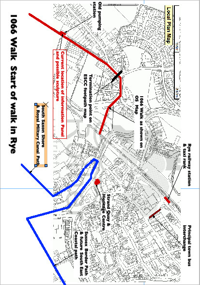
Image Credits: Kevin McCarthy , Rye Conservation Society .