

In this week’s edition of Rye News we are publishing a series of linked articles regarding the proposed Coast Path around England that will not be coming through Rye.
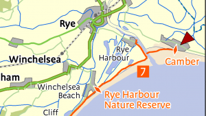
Following an article last week on the break in the path at Rye we have received a response from Councillor Keith Glazier, leader of East Sussex County Council (ESCC) and Rye’s representative on the council, on Natural England’s assessment that the A259 and Rye Harbour Road junction is dangerous, and they do not believe people on foot can cross it safely.
We have published Councillor Glazier’s response in full below. While Councillor Glazier claims the junction of the A259 and Rye Harbour Road is safe, this is not the opinion held by either Natural England or Rother District Council (whose Local Development Framework for Rye and Rye Harbour identified that improvements were needed to the junction).
It is also not clear that ESCC have anticipated the increased traffic that will be using the junction to access the new Discovery Centre at Rye Harbour Nature Reserve, as well as the increased commercial activity that is taking place along Harbour Road within its industrial units, and one could argue the modelling he refers to is out of date.
Councillor Glazier said, “Thank you for your email regarding Rye Harbour Road and the England Coast Path (ECP). For context, I have also given more detail below regarding the ECP and the process Natural England are following to implement this new route.
“England Coast Path – background: The England Coast Path (ECP) is a 2,500 mile round-Britain recreational walking route. Once in place, it will become a formal National Trail. Natural England (NE) is leading on this project and is working towards a deadline of December 2020.
NE’s funding for the project runs out at that time, so they are currently working ‘pragmatically’ to produce reports covering all stretches around the country.
“These reports are a key stage in the creation of the trail and are published by NE following liaison with path users, East Sussex County Council (ESCC), landowners and other statutory bodies. Each report covers a geographic stretch of the ECP and requires secretary of state approval before work can be started to create the route on the ground. Once the ECP is in place, the county council will become responsible for maintaining the national trail.
“In East Sussex, the Shoreham-Eastbourne stretch has recently been approved by the secretary of state. ESCC’s Rights of Way & Countryside Team is currently working with NE to create that stretch on the ground. That work mainly involves signposting.
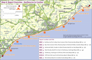
“The report covering the Eastbourne-Camber stretch has recently been published and is now being consulted on by NE. Due to the challenging funding deadline, NE are looking to create as much of the route as possible before the end of the year.
“Any ‘gaps’ in the ECP that cannot be resolved before then will be addressed at some point in the future – either by ESCC or a trail partnership. There are proposals to set up a London-Brighton ECP partnership to manage and fundraise for the trail once it has been formally opened.
“ECP proposals between Rye Harbour and Camber Sands: When designing a route for the ECP, NE work to their own internal guidelines and standards. As detailed in their online report, and in line with NE’s ECP guidelines, it has not been possible to propose a route between Rye Harbour and the western edge of Camber Sands. The challenging ECP funding timelines also limit the amount of time NE has to continue exploring other options in the Rye area.
NE guidelines differ
“The ECP is designed as a recreational national trail which aims to offer a quality ‘coastal’ experience. So, NE’s guidelines will differ from those used by ESCC to assess crossings and other public access scenarios.
“This means that NE have decided to publish the proposals for the Eastbourne-Camber stretch with a ‘gap’ in the trail between the mouth of the River Rother/Camber Sands and Rye Harbour town.
“While this is quite an unusual scenario for the ECP, it is likely to be occurring at several other locations around Britain, especially in mind of the funding deadline and NE’s current approach to getting the majority of the route in place.
“It is also worth bearing in mind that, when the now well-established and continuous South Downs Way (the only other national trail in East Sussex) originally opened in the 1970s, it also featured several ‘missing link’ sections. Over time, these gaps have been resolved by the South Downs Way’s managers. Any such gaps in the ECP can hopefully be dealt with in a similar fashion in the longer term. The two main areas which have led to a gap in the ECP being proposed are at Rye Harbour Road and Rye Golf Club.
Rye Harbour Road and the ECP
“ESCC’s Road Safety Team were asked by NE to make some comments on road safety grounds regarding specific queries about five locations along Rye Harbour Road, in relation to their proposed coastal path scheme. These comments were provided for NE to consider further as part of their future deliberations on the route of their path.
The A259 was not raised within these discussions as this road forms part of the trunk road network and is the responsibility of Highways England. The crossing of Rye Harbour Road at its junction with the A259 also falls within the curtilage of the trunk road. It was therefore recommended that NE seek advice from Highways England in relation to this location.
“The desire for a pedestrian island to assist pedestrians to cross Rye Harbour Road was a suggestion made by NE. At no time has the Road Safety Team indicated that an island is required at this, or any other, location. The Road Safety Team made it clear that they were not the designers for the Coastal Path Scheme and were only offering advice based on the proposals as presented and questions asked by NE.
“In addition, it was made clear that all the sites had been visited without the benefit of any details about likely numbers using the path and this made it more difficult to assess the likely impact on other road users. The Road Safety Team had previously assessed Rye Harbour Road to the A259 junction as part of a Home to School route.
A home to school assessment
“Home to School assessments are carried out in line with national guidance which helps local authorities decide whether a route would be considered available within the terms of the relevant criteria. This assessment did not take into account crossing the A259 at this location. There is a footway constructed on the east side of the road which then gives access to safe crossing points at Strand Quay.
“In terms of the Home to School assessment procedure, it is assumed that all footways offer an available route. The crossing at the junction of Rye Harbour Road would have been assessed in terms of traffic flow and gaps in the traffic. As the traffic flow was light to medium and adequate gaps were present, the crossing point was considered available in terms of the Home to School Assessment Guidelines.
“In conclusion, I would like to assure you that the Road Safety Team have not stated that it is not safe to cross the A259 or Rye Harbour Road at its junction with the A259 regardless of whether this relates to adults or children. I am also unable to comment on the outcome of any risk assessments undertaken by Natural England in relation to the routing of their coastal path although we continue to work with them to provide advice and assistance as requested.
Rye Golf Club
“Existing land use and the layout of the existing public rights of way network have made it difficult for NE to identify a currently viable route for the ECP in the vicinity of Rye Harbour Golf Club. Given the tight funding deadline, it was considered that the best approach would be to propose a ‘gap’ in the ECP at this point.
“The next steps: NE is consulting on the Eastbourne to Camber stretch until April 23 and more information is available on their site. Any comments regarding their proposals should be submitted to NE via: southeastcoastalaccess@naturalengland.org.uk After that deadline, and as it seems likely that objections will be made to this stretch of the ECP, then NE will refer the report to the secretary of state (SoS) for approval. If appropriate, the SoS will also look to resolve any outstanding objections.
“Once the Eastbourne to Camber stretch has been approved, ESCC will then work with NE to create the route of the ECP on the ground.”
Image Credits: Kevin McCarthy , Natural England .
So keith Glazier is not only our representative on East Sussex county council, but is also an expert on road safety,despite natural england assessment that the harbour road junction is dangerous to pedestrians, we also get the same old tiresome story from East Sussex County Council,no money available for extra services, so why was it not when the visitor centre was granted permission to build,the hundreds of thousands given to this project, that a proviso was put in place, some of the money was to be used to improve the harbour road junction, for the safety of their visitors,and local alike.We have also seen recently the chaos this council have caused by not putting two-way traffic lights in deadmans lane,whilst the bridge road closure has been in place, unnecessary inconvience to many people in Rye, thanks to the highways short sightedness, with Council elections delayed because of the Corona virus, it looks as if we have keith Glazier for another year, hopefully at the next election he will gracefully retire,and we can get somebody in place representing us, with the interests of the people of this town, and visitors alike.